|
Flood Warning and River Monitoring System for the Prut River
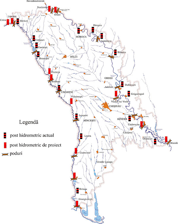
The catastrophic floods that affected Nistru and Prut rivers in the period 2008 - 2010 and the considerable material losses showed once again the need to establish an efficient automatic hydrological monitoring and early warning system, as a component of the flood risk reduction activities on the territory of the country. In this context, the State Hydrometeorological Service has received financial aid from the Czech Ministry of Environment and Czech Government for the reorganization and modernization of the hydrological monitoring of the Prut river surface waters. Such activities are carried out also on other river basins. So is the Moldo-Czech pilot-project implemented in 2008 on the Răut river, that resulted in installation of 5 hydrometric automatic posts. The Prut river is a left tributary of the Danube river. Its length is 953 km and its basin covers the territories of Ukraine, Moldova and Romania. The river spring is located in the Ivano-Francovsc region in Ukraine and at a distance of 100 km downstream, the Prut river changes its direction towards south and forms the natural boundary between Moldova and Romania. In 1978, in the Costeşti village of the RSSM Rîşcani district, in cooperation with Romania, there was built a dam, a reservoir and the Hydro-Power Plant Costeşti-Stînca. Thus, there were created conditions for regulating the Prut river water regime and for prevention of the catastrophic high waters. In 2010, on 11-13 March and 20-21 April, there was implemented the first phase of the Moldo-Czech project „ Flood Warning and River Monitoring System for the Prut River”, in cooperation with the Czech experts, namely there was carried out the visual prospection works and the determination of the hydrometric automatic posts locations. In the frame of the project it is foreseen to install, with the aid of Czech Government and Czech Development Agency, 11 hydrometric automatic posts (figure 1). The implementation of the project will allow the modernization of the hydrological monitoring on the transboundary Prut river through the implementation of a new warning system and through the improvement of the means of prevention and protection against floods, that will enhance the provision of the public, local and central authorities with operative information, hydrological forecasts and warnings.
Figure 1. The map of the hydrometric potst on the Prut and Nistru rivers
|